Ports & Logistics
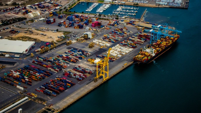
Aerial data for ports and terminals, covering quay wall and crane condition, perimeter security, cargo accounting, and stockpile volume tracking.
We give logistics operators a faster, more reliable way to check terminal and warehouse condition. SD Aerial covers structural checks, stockpile volumes and thermal scans in one pass, replacing separate manual walkthroughs. Racking, loading bays and fencing are checked for wear, stockpiles are measured without a manual count, and overheating equipment is flagged before it causes downtime.
Port surveys are scheduled around live operations, so a jetty or crane gets checked without halting a berth or a vessel schedule. Volumetric flights measure bulk cargo across active terminals, giving a verified figure instead of a manual estimate. Results are classified, geo-tagged and delivered as structured data, routed directly into the WMS, ERP or GIS system already in use. -
Structural inspection
Crane rails, quay walls and berthing structures take constant load, vibration and salt exposure, and in a marine environment small defects escalate quickly into safety and downtime risks. A manual check means sending someone up a crane or under a jetty by boat, and it only covers what's visible from that one position at that one moment, with the next check often weeks away.
We survey these structures with RTK precision, accurate to the centimetre, without taking a crane or berth out of service to do it. Every finding is classified by severity and delivered as structured data, not a set of photos someone still has to review and interpret manually.

Jetty condition survey
Structural imagery of jetties and berths, geo-tagged to the centimetre, flags cracking and deterioration before it becomes a safety issue. Surveys run on a recurring schedule or on demand, without pulling a structure out of service to inspect it.
Crane corrosion mapping
Thermal and structural data pinpoints corrosion on crane rails and gantry legs down to the exact section, rather than flagging a crane as generally in need of attention. Maintenance teams get a location and severity rating for every finding.
Post-incident survey
After a collision, storm or equipment failure, a rapid-response flight documents structural condition within hours, before repair work begins. The record is geo-tagged and timestamped, giving insurers a defensible basis for claims.
Cargo volume
A manual stockpile count is slow to run and slower to reconcile, and the estimate drifts further from reality the longer a pile sits between inspections. For terminals handling dry bulk or breakbulk cargo, that gap doesn't stay theoretical. It affects billing accuracy, inventory planning and the figures reported in contractual audits, and it tends to compound quietly across a busy season rather than showing up as a single obvious error.
A single RTK flight replaces the walkaround with a verified volume figure for every stockpile on site, delivered directly into the inventory system already in use rather than a PDF someone has to read and transcribe by hand.

Breakbulk volume audit
Dry bulk and breakbulk cargo is measured volumetrically across active berths in one RTK flight, without pausing loading or vessel movements. The result is a verified figure accurate enough to support billing and contractual reporting.
Stockpile reconciliation
Comparing each flight against the last one surfaces discrepancies between recorded and actual volumes while they're still small, before a gradual drift becomes a significant gap operators only discover during a full audit.
Thermal monitoring
Overheating equipment and improperly stored cargo often go unnoticed until they cause a shutdown, a fire risk or an insurance claim, because scheduled maintenance checks typically cover only part of a site at a time and run on a fixed interval regardless of what's actually changing on the ground. Between those fixed checks, a developing fault has room to escalate without anyone seeing it. A thermal flight covers the full yard in a single pass, and findings are ranked by severity and routed directly into the maintenance system already in use, arriving as a prioritised list rather than raw thermal footage someone still has to review frame by frame.

Yard hotspot detection
Overheating equipment, electrical faults and points of mechanical friction are flagged across the yard before they escalate. Because the entire site is covered in one flight, issues get caught before the next scheduled maintenance round.
Cargo storage monitoring
Temperature anomalies in stored cargo, including material prone to self-heating, are detected and geo-tagged early, before visible signs of spoilage. Storage teams get a location and severity level for each anomaly found.
Perimeter & security monitoring
A fence line running for kilometres makes it easy for a gap, a damaged section or an unauthorised opening to go unnoticed between scheduled security rounds, and ground patrols routinely struggle with blind spots created by stacked cargo, parked equipment or uneven terrain. Covering the full perimeter on foot also takes time, which is exactly why patrol routes tend to get shortened or skipped when a site is under pressure elsewhere.
An aerial survey covers the full boundary in a single flight, catching what a ground patrol structurally can't reach or see, and logs the result as a dated, geo-tagged record rather than a verbal report at the end of a shift.
Perimeter integrity check
Fencing, gates and every access point along the site boundary are surveyed in one flight for gaps or structural damage, producing a complete condition record rather than the sampled coverage a walking patrol manages in the same amount of time.
Lighting & camera coverage audit
Aerial imagery is checked against actual site geometry to flag blind spots in existing lighting and CCTV coverage, including gaps created by stacked cargo or new construction since the camera layout was originally planned.
Why we're not just another drone company?
Faster turnaround
Findings are delivered within hours of a flight, not days after a manual audit and its written report.
Zero operational downtime
Flights are scheduled around live loading, unloading and vessel movements, so a survey never forces a pause in operations.
Direct system integration
Results are delivered straight into the WMS, ERP or GIS platform already in use, with no manual re-entry or separate report to file.
Full-site coverage in one flight
A single flight covers structural, thermal and volumetric checks across an entire site, replacing several separate manual walkthroughs.
Verified, audit-ready figures
Volumetric and condition data is accurate enough to support billing, inventory reporting and insurance claims.